Latest update From TNB via Bernama:
Water Release From Sultan Abu Bakar Dam Was Inevitable - TNB
KUALA LUMPUR, Oct 28 (Bernama) -- The rapid increase of the Ringlet Lake water level within a short period of time late Tuesday and early Wednesday last week, was an exceptional situation for the Ringlet Reservoir, said TNB president and chief executive officer Datuk Seri Azman Mohd.
He said the unusually intense downpours on Oct 22 and 23 had brought huge volumes of water to the lake, together with solid wastes, debris and siltation from what was described as massive land clearing and farming activities upstream.
The rubbish clogged up the Bertam Water Intake, an outlet where water from the reservoir normally flows before entering the Bertam tunnel to underground power generation units.
Such accumulation of siltation and sediment had reduced the reservoir's holding (water) capacity.
"As a result, for the first time in the history of the 50-year-old reservoir, water level surged at a rate of 1.96 feet per hour, which was 13 times more than the normal monsoon rain condition," he said in a statement here Monday.
According to the statement, surplus water had to be discharged in stages from the Sultan Abu Bakar dam to avert the dam's automatic full spillage through all four spillway gates that would have caused greater destruction to the occupants of Bertam Valley.
Four people were confirmed dead, following a flash flood when Sungai Bertam overflowed following the release of water from the Sultan Abu Bakar Dam, Ringlet, Cameron Highlands on Oct 23.
The incident also destroyed about 80 houses and several cars in the Bertam Valley settlement areas.
The TNB statement explained that by design, a spillway gate is a dam protective structure used to provide the controlled release of water flow from a dam into a downstream river.
Downstream area should be clear of people and structures, it added.
Azman said given the challenge of these external factors, which were beyond TNB's control, it was impossible to give advance notice to immediately evacuate the water release pathway other than what had already been done in the circumstances.
"While we could and should be continually improving our standard operating procedures (SOP), given the circumstances, we seriously doubt whether any SOP can be fully effective in averting such a disaster," he said.
He also said that no one should have lived in the path of the dam's water release and the weather elements, together with the development activities, had introduced greater unpredictability to the situation.
"We're continually monitoring the situation and we experienced a rate of rise of water level of 1.2 feet per hour from 4pm to 6pm Sunday. A sudden blockage of the power station's intake can trigger another catastrophe.
"People living in the area are still not out of the woods yet, as development activities that have caused the Bertam reservoir to lose its water holding capacity continue to gain momentum," he added.
"We don't think anybody can guarantee the safety of the people at the site given the present conditions. Thus, they should be kept out of harm's way and vacate the area," he added.
-- BERNAMA
Original Post:
A bit on the recent mud flood tragedy at Cameron Highlands:

Here is angry Ravinder Singh saying:
My thots:
1. When we talk about monitoring water levels we are actually talking about the capacity of the Dam to retain water behind it. The dam level being monitored must be calibrated to the existing storage capacity of the dam to ensure accurate and timely warning to the people downstream of the dam.
Reservoir Silting
Read in full here.
Water Release From Sultan Abu Bakar Dam Was Inevitable - TNB
KUALA LUMPUR, Oct 28 (Bernama) -- The rapid increase of the Ringlet Lake water level within a short period of time late Tuesday and early Wednesday last week, was an exceptional situation for the Ringlet Reservoir, said TNB president and chief executive officer Datuk Seri Azman Mohd.
He said the unusually intense downpours on Oct 22 and 23 had brought huge volumes of water to the lake, together with solid wastes, debris and siltation from what was described as massive land clearing and farming activities upstream.
The rubbish clogged up the Bertam Water Intake, an outlet where water from the reservoir normally flows before entering the Bertam tunnel to underground power generation units.
Such accumulation of siltation and sediment had reduced the reservoir's holding (water) capacity.
"As a result, for the first time in the history of the 50-year-old reservoir, water level surged at a rate of 1.96 feet per hour, which was 13 times more than the normal monsoon rain condition," he said in a statement here Monday.
According to the statement, surplus water had to be discharged in stages from the Sultan Abu Bakar dam to avert the dam's automatic full spillage through all four spillway gates that would have caused greater destruction to the occupants of Bertam Valley.
Four people were confirmed dead, following a flash flood when Sungai Bertam overflowed following the release of water from the Sultan Abu Bakar Dam, Ringlet, Cameron Highlands on Oct 23.
The incident also destroyed about 80 houses and several cars in the Bertam Valley settlement areas.
The TNB statement explained that by design, a spillway gate is a dam protective structure used to provide the controlled release of water flow from a dam into a downstream river.
Downstream area should be clear of people and structures, it added.
Azman said given the challenge of these external factors, which were beyond TNB's control, it was impossible to give advance notice to immediately evacuate the water release pathway other than what had already been done in the circumstances.
"While we could and should be continually improving our standard operating procedures (SOP), given the circumstances, we seriously doubt whether any SOP can be fully effective in averting such a disaster," he said.
He also said that no one should have lived in the path of the dam's water release and the weather elements, together with the development activities, had introduced greater unpredictability to the situation.
"We're continually monitoring the situation and we experienced a rate of rise of water level of 1.2 feet per hour from 4pm to 6pm Sunday. A sudden blockage of the power station's intake can trigger another catastrophe.
"People living in the area are still not out of the woods yet, as development activities that have caused the Bertam reservoir to lose its water holding capacity continue to gain momentum," he added.
"We don't think anybody can guarantee the safety of the people at the site given the present conditions. Thus, they should be kept out of harm's way and vacate the area," he added.
-- BERNAMA
Original Post:
A bit on the recent mud flood tragedy at Cameron Highlands:
 |
| The Star: Three killed in mud flood after water released from Cameron Highlands dam |
My thots:
1. When we talk about monitoring water levels we are actually talking about the capacity of the Dam to retain water behind it. The dam level being monitored must be calibrated to the existing storage capacity of the dam to ensure accurate and timely warning to the people downstream of the dam.
2. The Sultan Abu Bakar Dam is operated by the TNB, though I believe the upstream catchment area is not handled by them.
3. The silt and mud caused by erosion due to exposed land terrains from the upstream catchment area will find its way through the network of streams and rivers into Ringlet lake where the Dam is situated. (see above graphic)
4. The silt buildup behind the dam over time will cause the Ringlet lake to become shallow and the shallower it gets the lesser will the storage capacity of the dam will be.
5. With climactic change, the monsoon when it comes will probably bring more rain than usual in future, more rains means more erosion, more erosion means more silt flowing into Ringlet lake. It will tremendously help the situation better i.e improve the storage capacity of the Ringlet lake if TNB/authorithies concerned have a long term maintenance dredging contract to ensure that Ringlet Lake will be deepened to the design parameters of the dam storage capacity at all times. (I understand TNB is doing some form of desilting/dredging projects at Ringlet lake, but do not know the frequency or when the last time it has been dredged)
6. Yes! instead of spending big money improving the Sungai Bertam, perhaps the maintenance dredging of Ringlet Lake should be given more priority.
7. Better still the catchment area upstream of Ringlet lake must also be closely monitored for illegal land clearing for farming or logging as this activities destroys the natural cover of the terrain and causes runoff which carries silt into streams and rivers..and end up to now you know where.
 |
| NST pic: Aerial view of Sultan Abu Bakar Dam |
Hope my 2 cents worth could enlighten a bit, I am sure the technical investigations will reveal more and the learned ones will come up with better recommendations... such as for timely warnings to be issued to residents affected, maintenance of spillway gates, maintenance dredging of lake behind dam etc.etc to be used for all dams in the country not just the one at Cameron Highlands.
Interesting read:
Reservoir Silting
River terminology
Watershed
|
The area that supplies a river with water and sediment
|
Mouth of the river
|
Part where the river joins the ocean/sea, lake or another river
|
Reach
|
Any stretch or part of a river along its length upstream from the mouth
|
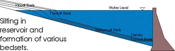
A reservoir is formed upstream to a dam. – Sediment coming to the reservoir is largely deposited in it and sooner or later – reservoir is silted – filled up with sediment and the usefulness of the dam is lost. The presence of the dam retards the natural flow and hence the water level in the reservoir is not horizontal but its surface is slightly curved (Backwater curve). When the river flow reaches the reservoir the flow velocity decreases and coarser particles such as sand are dropped close to the entrance. The beds formed this way are called foreset beds.
Fine sediments are settled slowly across the area of the reservoir. These are known as bottom set beds. Foreset beds obstruct the flow still forthcoming from the upstream and formation and propogation of topset beds occur. As time goes on the foreset beds advance into the reservoir to form higher & higher slopes, which because of its height will not stand so steeply as the slopes formed earlier. Hence the high slopes of the foreset beds have to flatten out and cover a part of the previously laid bottomset beds. This causes an intermixture of coarser and finer sediments at the bottom of the reservoir.
The location of future silt deposit in a reservoir can often be predicted.
A) Sediment will deposit near the dam if;
i. The reservoir water surface is at low elevation
ii. There is high percentage of clay to fine silt size
iii. The reservoir is short and has a steep slope to the original valley floor.
iv. There is little or no vegetation near the head of the reservoir
v. The dam has small outlet at higher elevation.
click link below for dam cross section
B) Sediment will deposit at the head of the reservoir it;
i. The conditions are converse to above.
Reservoir life: Reservoir capacity expressed in acre/cu.ft [1 acre ft. = 43.560 cu.ft]
Factors to estimate the life:
· How long it will continue to store a useful amount of water - length of time the water stays in the reservoir before being used.
· The rate with which the sediment accumulates from year to year and is not removed by natural devices.
· If the storage space become less – these is an increase in the rate at which fine sediment leaves the reservoir.
· Silt at a high level in the reservoir – removable by dredging (though costly) silt in live storage. Silt in dead storage (low level) cannot be removed.
· Reservoir life can be extended by sluicing operations the outlet gates are opened at appropriate interval and the high velocity flows carry some of the sediment downstream.
· If this is timed to intercept gravity underflows – the sediment removal can be very efficient. However, it is ineffective about the sediment, which is already settled.
This is no time for finger pointing.
Finger pointing does not solve problem, it exacerbates the situation.
No comments:
Post a Comment